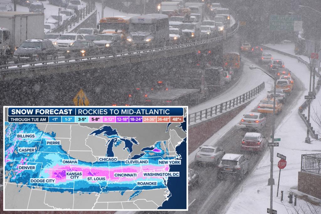
A potent winter storm, fueled by a polar vortex descending from the Arctic, is poised to blanket the New York City metropolitan area with 1 to 3 inches of snow on Monday. The storm’s arrival coincides with the morning commute, with heavier snowfall anticipated between noon and 4 p.m., potentially significantly impacting the evening rush hour. Mayor Eric Adams has urged residents to exercise caution while outdoors and on the roads, assuring the public that city snow crews will be diligently working to maintain clear roadways throughout the weather event. Beyond the snowfall, the primary concern revolves around the plummeting temperatures, which are expected to remain in the low 30s throughout the day, dipping into the 20s during the morning and evening hours.
While forecasts predict a potential accumulation of up to 3 inches of snow, meteorologists suggest that the actual snowfall is more likely to be closer to 1 inch across northern New Jersey and Long Island. Areas north of the city, including the Hudson Valley and Connecticut, are expected to experience a wintry mix rather than substantial snowfall. The impending winter storm is a direct consequence of a seasonal polar vortex, a large-scale system of cold air circulating around the poles. This vortex has already unleashed a significant winter storm across the central United States over the weekend, impacting states from Kansas and Missouri eastward to Illinois, Indiana, and Ohio with snow, ice, and freezing temperatures.
While the majority of the tri-state area is expected to avoid the worst of this storm, southern New Jersey, particularly areas from Toms River southwards, is projected to receive a significantly higher snowfall, potentially accumulating up to 8 inches or more starting Sunday night. This discrepancy in snowfall accumulation is due to the storm’s trajectory and the influence of local geographic factors. The polar vortex, responsible for driving this frigid weather system, is a common meteorological phenomenon during winter months, characterized by a large area of low pressure and cold air surrounding both of Earth’s poles. Its southward movement can bring significantly colder temperatures and winter precipitation to regions further south.
The frigid conditions are anticipated to persist throughout the remainder of January, with morning temperatures consistently in the low to mid-20s, rising only to the low to mid-30s during the day. This sustained period of cold weather signifies a marked shift from the relatively milder temperatures experienced at the close of December. The likelihood of temperatures reaching the 40s, as experienced briefly in the previous month, remains low for the coming weeks. This extended period of cold weather underscores the importance of preparedness for residents of the tri-state area, including ensuring adequate heating, protecting vulnerable populations, and taking necessary precautions for outdoor activities.
The impending winter storm and sustained cold spell highlight the influence of large-scale atmospheric patterns like the polar vortex on regional weather. These patterns can bring about significant shifts in temperature and precipitation, demanding careful monitoring and preparation from both meteorological agencies and the public. The contrast between the milder end of December and the abrupt arrival of this frigid January weather underscores the dynamic nature of winter weather and the importance of staying informed about forecasts and potential hazards. The city’s preparation, including the deployment of snow crews and public advisories, demonstrates the awareness of the potential disruptions posed by such weather events.
The combination of snowfall and significantly low temperatures poses multiple challenges, including potential disruptions to transportation, increased risk of hypothermia and other cold-related illnesses, and the potential for power outages due to increased energy demand. Public awareness and appropriate precautionary measures are crucial for mitigating these risks. The extended duration of the cold spell, expected to persist through the end of January, emphasizes the need for sustained vigilance and preparedness throughout this period. The advice from Mayor Adams to exercise caution, especially during commutes, underscores the potential for hazardous road conditions due to snow and ice. The city’s proactive measures to address the anticipated challenges highlight the importance of coordinated efforts to ensure public safety during severe weather events.


