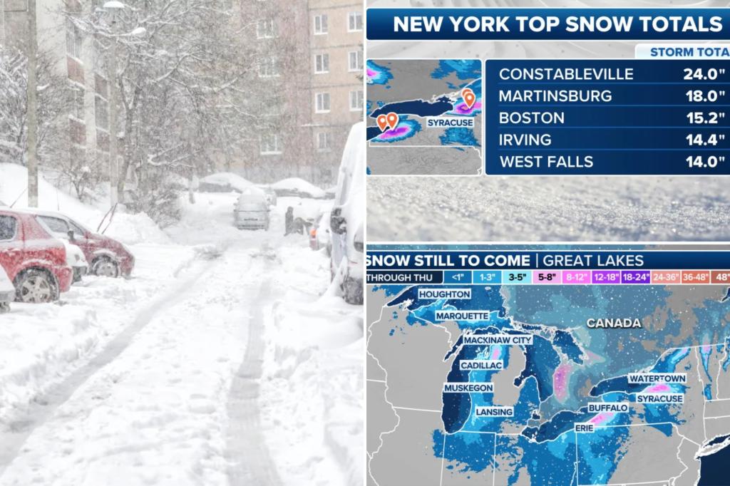
The Great Lakes region, particularly western New York and northwestern Pennsylvania, continues to be pummeled by relentless lake-effect snow, with the latest event leaving over 650,000 residents under winter weather alerts. This persistent snowfall has resulted in accumulations ranging from 14 to 24 inches in some areas, further adding to already impressive seasonal totals. Towns like Constableville, New York, have witnessed snowfall amounts nearing 10 feet since the beginning of winter, with the latest storm contributing an additional two feet. Other locations, including Martinsburg and Irving, New York, recorded significant accumulations as well, with 18 and 14.4 inches respectively. This heavy, localized snowfall, characteristic of lake-effect events, has created hazardous travel conditions, prompting authorities to issue warnings and advisories.
The brunt of the snowfall has concentrated south of Buffalo, New York, impacting areas around Erie, Pennsylvania, and regions south of Watertown, New York, along the eastern shore of Lake Ontario. Watertown itself has accumulated over five and a half feet of snow this season, highlighting the intensity and persistence of these lake-effect events. This latest round, commencing late Monday night and continuing through Tuesday, created particularly treacherous conditions on the New York State Thruway south of Buffalo, with strong snow bands severely impacting visibility and road travel. FOX Weather Storm Trackers captured the challenging conditions, documenting rescues of stranded vehicles and reporting near-whiteout conditions in several locations.
While the immediate focus remains on the areas currently under Lake-Effect Snow Warnings, which are expected to expire late Wednesday night, a shift in the snow bands is anticipated. Meteorologists observed a southeasterly shift in the direction of the bands emanating from Lakes Erie and Ontario on Wednesday morning, potentially expanding the impact area. This shift brings Syracuse, New York, into the potential snowfall zone, placing the city under a Winter Weather Advisory. Furthermore, brief but intense snow squalls could reach as far south as central Pennsylvania and northern New Jersey, highlighting the far-reaching effects of these lake-effect events.
This marks the fourth significant lake-effect snow event to impact the region this winter season. Previous events, including one in mid-December, have caused significant disruptions, including multiple vehicle crashes and major traffic delays along Interstate 90 south of Buffalo. A recurring pattern this season has directed the heaviest snow bands and highest accumulations towards Erie, Pennsylvania, and the surrounding I-90 corridor. This has resulted in a stark contrast in snowfall totals between Erie, which has recorded over 86 inches of snow, and Buffalo, which has received a considerably lesser amount, slightly under 30 inches.
The impact of this lake-effect system extends beyond western New York and Pennsylvania, reaching into Michigan’s Upper Peninsula and the western shores along Lake Michigan. Petoskey, Michigan, located in the northern part of the state, accumulated 11 inches of snow between Monday and Tuesday, demonstrating the widespread reach of this weather system. The combination of cold air masses moving over the relatively warmer lake waters fuels these intense, localized snow events, creating hazardous conditions and disrupting travel across multiple states.
As this particular lake-effect event winds down late Wednesday night, the respite may be short-lived. Forecast models indicate the potential for another weather system, a clipper system, to move into the region late Thursday and early Friday, bringing further snowfall. This continuous onslaught of winter weather emphasizes the challenges faced by residents and transportation authorities in managing the impacts of these recurring snow events. The potential for additional snow accumulation necessitates continued vigilance and preparedness, as communities brace for the next wave of winter weather.

