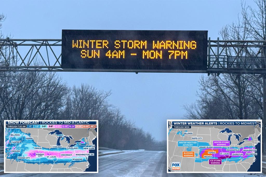
A potent winter storm, the first major one of the year, is sweeping across a vast 2,100-mile stretch of the United States, impacting regions from the Northwest and Plains to the Mid-Atlantic and East Coast. This extensive system, which initially brought the year’s first tornado to California and then traversed the northern Rockies and central Plains, is now posing a multifaceted threat to major metropolitan areas. The storm’s arsenal includes heavy snow, near-blizzard conditions, and treacherous ice accumulations, with the potential to cause widespread and prolonged power outages. Millions of residents are under winter weather alerts, bracing for the storm’s impact.
The initial stages of the storm saw freezing drizzle transform roadways into ice rinks in Wichita, Kansas, offering a glimpse of the travel chaos to come. Accidents surged across the Wichita metro area, straining law enforcement resources and prompting urgent pleas from the National Weather Service for residents to stay home. Interstate 70 experienced multiple closures due to cascading crashes, further hindering travel and emergency response efforts. The storm’s trajectory has placed over 64 million people under winter weather alerts, including Winter Storm Warnings and Ice Storm Warnings, with the region between Interstates 50 and 70 expected to bear the brunt of the impact.
As the storm progresses, blizzard conditions are anticipated across portions of Kansas and Missouri, reducing visibility drastically and creating hazardous driving conditions. Strong winds, gusting up to 50 mph, are expected to exacerbate the blizzard conditions through early Monday. These blizzard warnings, a rarity for major metro areas like Wichita and Kansas City in recent years, underscore the severity of this winter event. Simultaneously, further south, a significant ice storm is developing, threatening to encase regions from southern Missouri through Kentucky and into West Virginia with up to an inch of ice. This heavy glaze poses a serious risk of extended power outages, particularly in areas with challenging terrain that hinders repair efforts.
This winter storm is projected to be the most significant snowfall event of the season so far, and for some areas, potentially the largest in over a decade. Snowfall totals are expected to approach a foot in Kansas, Missouri, Illinois, Ohio, and parts of West Virginia. The Appalachians and Great Lakes regions may see even higher accumulations due to terrain effects. Communities in the storm’s path have declared snow emergencies and mobilized crews for around-the-clock snow removal efforts, recognizing the scale of the impending challenge. Major interstates, including I-70 and I-44, are anticipated to become virtually impassable, further disrupting travel and commerce.
The heavy snow will give way to a significant ice storm further south, with prolonged periods of freezing rain anticipated. Ice accumulations of at least half an inch are expected in parts of southern Missouri, southern Illinois, and the Appalachian Mountains, posing a considerable threat to power infrastructure and trees. Strong winds accompanying the ice storm are likely to exacerbate the damage, causing ice-laden branches to snap and take down power lines, leading to widespread and potentially long-lasting outages. The combination of heavy snow and ice accumulation is expected to cause significant disruptions to daily life, including school closures and travel delays.
The ice accretion has already caused temporary closures at Kansas City International Airport, impacting flights and highlighting the storm’s immediate effects on transportation. Major airlines are offering travel waivers to passengers in anticipation of further disruptions. The lingering cold air following the storm’s passage will ensure that the snow and ice remain for an extended period, unlike previous winter weather events this season that were followed by rapid thaws. This prolonged cold snap will compound the challenges posed by the storm and necessitate ongoing preparedness for several days. The storm’s impact extends beyond travel disruptions, with sporting events also affected.
Beyond the snow and ice, the storm system’s warm side is fueling severe thunderstorms across the South, with risks of damaging winds and tornadoes. A Level 3 out of 5 risk for severe storms has been issued for parts of northern Louisiana, western Mississippi, and southeastern Arkansas, with a broader Level 2 risk encompassing East Texas to western Alabama. These thunderstorms are particularly concerning as they threaten regions still recovering from a tornado outbreak in late December. Severe thunderstorms during winter months are not uncommon in the South, which experiences a distinct tornado season during this period.
The confluence of heavy snow, blizzard conditions, significant ice accumulation, and severe thunderstorms makes this a particularly hazardous and complex winter storm. The widespread impact across multiple states, the potential for prolonged power outages, and the disruption to travel underscore the need for preparedness and vigilance. The declaration of states of emergency and preparedness by several governors reflects the seriousness of the situation and the need for coordinated response efforts. The storm’s aftermath, with lingering cold temperatures and the potential for extended power outages, will likely continue to pose challenges in the affected regions. The storm serves as a stark reminder of the disruptive power of winter weather and the importance of heeding warnings and taking necessary precautions.


