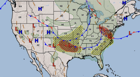
As of early Monday, a significant winter storm system gripped a large swathe of the United States, prompting winter storm warnings across seven states and winter weather advisories in others. The National Weather Service (NWS) forecasted heavy snowfall, with some areas expected to receive up to 17 inches. This severe weather event posed a significant threat to holiday travelers, potentially causing hazardous driving conditions and travel disruptions. The NWS strongly advised drivers to reconsider travel plans if possible and to exercise extreme caution if travel was unavoidable.
The affected states under winter storm warnings included Oregon, Washington, Idaho, Montana, South Dakota, Wyoming, and Colorado. Utah was under a winter weather advisory. Specifically, the warnings encompassed Northwest Oregon, western Washington, Northern Idaho, and central Montana. Wyoming’s western regions were also under warnings, as was a localized area in western South Dakota. The Black Hills region of South Dakota was particularly vulnerable, with forecasts predicting up to 17 inches of snow accumulation in higher elevations. Utah’s central region was under an advisory alongside the majority of Montana and a large portion of South Dakota. This widespread impact underscored the seriousness of the storm and its potential to disrupt travel and daily life for many.
The NWS issued urgent warnings about hazardous driving conditions, urging travelers to prepare adequately. Recommendations included checking tire chain requirements and equipping vehicles with emergency supplies like flashlights, extra food, and water. These precautions were crucial given the potential for road closures, accidents, and delays.
The NWS issues winter storm warnings when a significant combination of hazardous winter weather is occurring or imminent. These warnings are triggered by several factors: five or more inches of snow/sleet within 12 hours, seven or more inches within 24 hours, enough ice accumulation to damage trees or power lines, or a life-threatening combination of snow and/or ice with wind. These criteria highlight the potential for severe impacts on infrastructure and public safety. In contrast, winter weather advisories are issued for less severe conditions, such as freezing rain or when two to four inches of snow are expected to cause significant inconvenience.
The NWS Cheyenne, Wyoming office provided specific forecasts for their region via social media, predicting cold temperatures and a chance of snow, primarily in southeast Wyoming on New Year’s Eve. High temperatures were expected to range from 24 to 36 degrees Fahrenheit, dropping to four to 16 degrees overnight. The Nebraska Panhandle was forecast to experience slightly warmer overnight lows of nine to 13 degrees. These forecasts reinforced the need for preparedness and caution in the affected areas.
The duration of the winter storm warnings varied across the different states, but many were in effect until 6 p.m. Monday. This meant that travelers faced challenging conditions throughout the day, and ongoing monitoring of weather updates was crucial for safe travel decisions. The widespread nature of the storm and its impact on multiple states underscored the need for vigilance and preparedness, particularly during the busy holiday travel period. The NWS’s clear communication and warnings were critical in helping the public understand the risks and take necessary precautions. This extensive winter storm served as a stark reminder of the power of winter weather and its potential to disrupt lives and travel. The combination of heavy snow, ice, and potentially strong winds created a hazardous environment, underscoring the importance of heeding weather warnings and preparing for the worst-case scenario.


