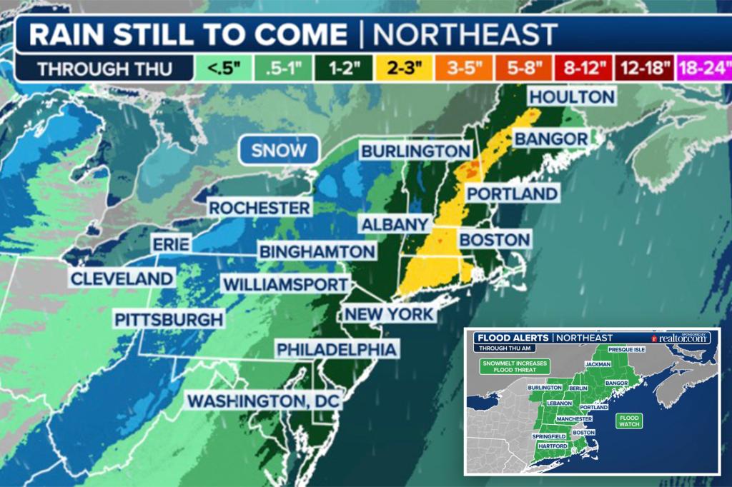
A potent storm system is poised to disrupt travel and daily life across the Northeast over the coming days, bringing a trifecta of heavy rain, powerful winds, and severe weather along the I-95 corridor, while simultaneously blanketing areas around the Great Lakes with heavy, travel-impeding snow. This multifaceted weather event began its disruptive journey on Tuesday with showers and thunderstorms across the South, but the most significant impacts are anticipated to unfold on Wednesday and Thursday.
The storm’s trajectory indicates widespread rainfall totals of 1-3 inches from the Appalachians through the Northeast, with localized areas potentially experiencing even higher amounts. Major cities such as Boston, New York City, and Baltimore are within this heavy rainfall zone, and airport delays have already been reported. While this precipitation is a welcome reprieve for much of the drought-stricken Northeast, the rapid rate of rainfall raises concerns about potential flooding. Flood Watches have been issued for millions of residents, particularly in Vermont, New Hampshire, and Maine, where the combination of rainfall and snowmelt could overwhelm drainage systems and waterways.
Adding to the complexity of this weather system is the threat of severe thunderstorms. Over 10 million people from the Carolinas to New England are under a Level 2 out of 5 risk of severe weather, as designated by NOAA’s Storm Prediction Center. This elevated threat level, the highest December severe weather risk for New York City since 2010, underscores the potential for damaging winds, hail, and even isolated tornadoes. The Northeast remains the epicenter for this hazardous weather, facing the triple threat of flooding rain, inland snow, and powerful winds throughout Wednesday and into early Thursday.
The storm’s intensity is further amplified by a strong pressure gradient, which is expected to generate near-hurricane-force winds along the coastline. Wind gusts of 40-60 mph are anticipated between New York City and Boston, areas currently under High Wind Warnings. These powerful winds pose a significant threat to trees, power lines, and even holiday decorations. Experts recommend securing outdoor decorations with stakes, sandbags, or twine, or temporarily storing them indoors until the storm passes, to prevent wind damage and potential power outages.
Air travel disruptions are also anticipated. While delays on Tuesday remained relatively minor, ranging from 30 minutes to an hour, more extensive delays are projected for Wednesday and into Thursday morning as the storm intensifies. Travelers are advised to check with their airlines for updates and potential cancellations. The storm’s aftermath will usher in a chilly air mass for the remainder of the workweek, a stark contrast to the preceding tempestuous conditions. By midday Thursday, the most significant hazards are predicted to move offshore, leaving behind a calmer but colder landscape.
Beyond the Northeast, the storm’s influence extends to the Mid-Atlantic and the Great Lakes region. Isolated severe thunderstorms are possible in eastern Virginia and North Carolina on Wednesday, fueled by a combination of warm air temperatures and high dew points. While most thunderstorms are expected to remain below severe criteria, they still carry the potential for torrential rainfall and lightning. The region’s recent lack of precipitation reduces the widespread flooding risk; however, localized flooding remains a concern in areas with poor drainage or terrain altered by previous storms like Hurricane Helene. This inclement weather is expected to move offshore by Thursday morning, ushering in cooler and drier conditions. Meanwhile, the Great Lakes region will contend with a resurgence of lake-effect snow from Wednesday through Friday. Communities east of Lake Erie, Lake Ontario, and Lake Michigan are forecast to receive substantial snowfall, with accumulations of 10-20 inches or more anticipated, prompting Lake Effect Snow Warnings for nearly 2 million residents. Travel conditions are expected to deteriorate significantly from Thursday into Friday, as blowing snow reduces visibility and creates hazardous driving conditions, particularly along Interstates 90 and 81. Looking ahead, a significant warm-up over the weekend and into next week is predicted to halt the lake-effect snow and melt the accumulated snowpack rapidly, raising concerns about potential flooding in the medium and long-term forecasts.


