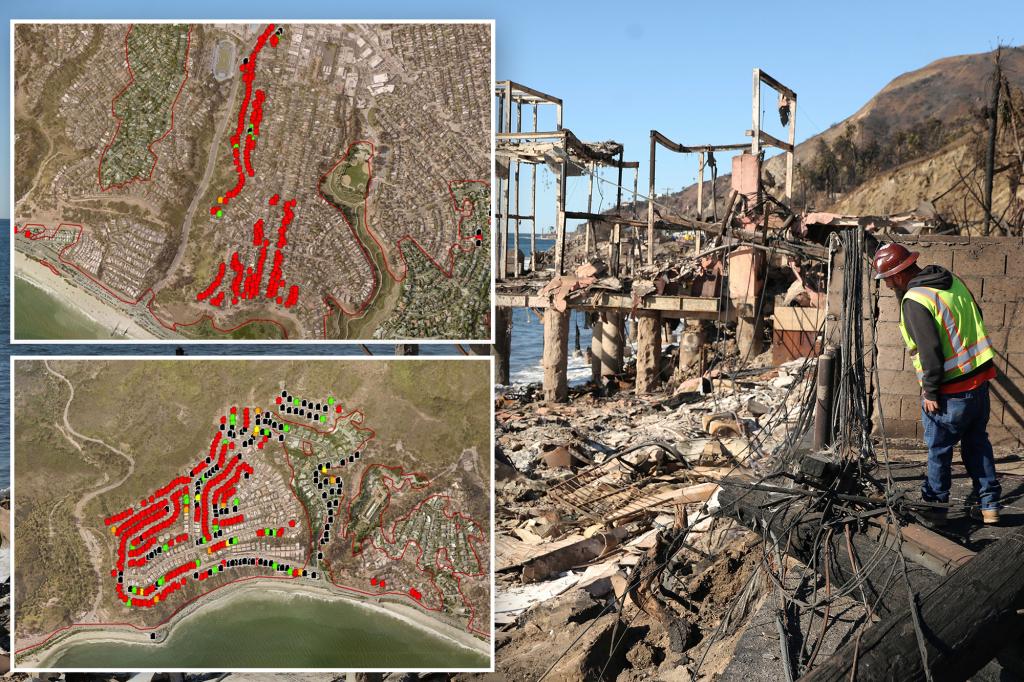
The devastating wildfires tearing through Los Angeles County, the Palisades Fire and the Eaton Fire, have left a trail of destruction, transforming once vibrant neighborhoods into landscapes of ash and ruin. Shocking new maps, created by LA County Recovers, provide a stark, house-by-house perspective of the damage, highlighting the capricious nature of the flames and the immense scale of the disaster. Entire blocks have been reduced to rubble, while in some instances, homes just streets away remain untouched, a grim testament to the unpredictable path of the fires. The maps utilize a color-coded system to depict the level of damage: black for spared structures, green for minor damage, orange for significant damage, and red for complete destruction. However, the sobering reality is that many structures remain uninspected, leaving a chilling uncertainty for residents awaiting news of their homes. The scale of the combined destruction already surpasses 59 square miles, an area more than double the size of Manhattan.
The Palisades Fire, burning near the Pacific Ocean in some of Los Angeles’ most exclusive zip codes, has scorched over 23,000 acres and tragically claimed at least eight lives. Aerial views of the affected areas reveal the utter devastation, with entire neighborhoods razed to the ground. As of Monday morning, the fire was only 13% contained, a grim indicator of the ongoing battle firefighters face against the relentless flames. The estimates of destroyed homes in the Palisades Fire alone are staggering, with officials suggesting the number could exceed 5,000. The cause of the fire is still under investigation, but a leading theory suggests it may have been a reignition of scorch marks from an earlier fire started by fireworks on New Year’s Eve, fueled by the powerful Santa Ana winds. This underscores the lingering danger even after a fire has seemingly been extinguished.
The Eaton Fire, a separate inferno burning near Pasadena, has proven even more deadly, claiming at least 16 lives and becoming the fifth deadliest wildfire in California history. It has consumed over 14,000 acres, leaving entire communities smoldering in its wake. The interactive maps starkly illustrate the widespread devastation, with blocks reduced to ashes. While some homes miraculously escaped unscathed, others were completely consumed, leaving only remnants of their former existence. The Eaton Fire was 27% contained as of Monday morning, after six grueling days of firefighting efforts. The cause of this fire is also still under investigation.
The combined impact of these two fires has been catastrophic. Over 12,000 structures have been destroyed, and at least 24 lives have been lost, with the grim expectation that the death toll will rise as search and rescue efforts continue. More than 153,000 residents are under evacuation orders, forced to flee their homes and seek refuge in shelters, adding to the human cost of this disaster. The fires have not only destroyed physical structures but also shattered lives, leaving individuals and families grappling with loss and uncertainty.
The ongoing threat of strong winds further complicates the situation, creating the potential for the fires to spread rapidly and inflict even more damage. Despite the significant progress made by firefighters over the weekend, the resurgence of strong winds early in the week poses a significant challenge to containment efforts. The tireless work of firefighters battling the flames is a testament to their dedication and bravery, but they face an uphill battle against the unpredictable nature of the fires, fueled by the dry conditions and strong winds.
The aftermath of these devastating fires will leave a long-lasting impact on the affected communities. The rebuilding process will be lengthy and arduous, requiring substantial resources and support. The loss of homes, businesses, and, most tragically, lives will leave scars on the landscape and within the hearts of the residents for years to come. The immediate focus remains on containing the fires and providing aid to those affected, but the long road to recovery will require a sustained effort from individuals, communities, and government agencies alike. The maps provide a stark visualization of the current destruction, serving as a reminder of the immense challenges ahead and the importance of preparedness and resilience in the face of natural disasters.


