An impending winter storm, originating from the Rockies, is poised to unleash a wave of frigid Arctic air across a vast swathe of the United States, reaching as far south as Florida. This surge of cold weather, predicted to commence on Friday and persist through the following week, carries significant implications for travel, infrastructure, and public health. Much of the nation has already grappled with challenging winter conditions this season, and this new storm threatens to exacerbate the existing challenges.
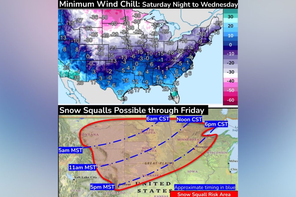
The National Weather Service (NWS) has issued warnings about the severity of the approaching cold front. Arctic air will initially sweep across the Rockies and Great Plains on Friday, progressing eastward to engulf the Deep South and Great Lakes by Saturday night. By Sunday evening, the Eastern Seaboard will be in the grip of the coldest air of the season so far. The NWS has highlighted the potential for dangerously low wind chills, particularly in the Rockies, northern Plains, and Upper Midwest, where temperatures could plummet to between -30 and -50 degrees Fahrenheit from Saturday through Tuesday. Even the southern Plains and Ohio Valley are expected to experience below-zero wind chills from Sunday night into Tuesday.
Adding to the complexity of the situation, heavy snow squalls are anticipated along the leading edge of the cold front. These intense bursts of snowfall, coupled with strong winds, can create hazardous whiteout conditions, drastically reducing visibility and making travel extremely dangerous. The NWS has identified several states, including Montana, North Dakota, South Dakota, Wyoming, Minnesota, Nebraska, and Iowa, as being particularly at risk for these snow squalls through Friday. As the front progresses, the threat of snow squalls will shift eastward.
The potential impact of this storm has prompted concerned commentary from meteorologists across the country. Experts are emphasizing the severity of the cold, urging preparedness and caution. Predictions suggest significant snowfall across a wide band stretching from Southeast Texas through parts of Louisiana, Mississippi, Alabama, Georgia, and into the Carolinas. The Deep South, in particular, is bracing for a prolonged period of frigid temperatures, with some areas potentially remaining below freezing for four to five days. The unusual reach of this cold air mass deep into the South underscores the significance of this weather event.
Beyond the immediate threat of snow and extreme cold, the impending storm raises concerns about potential power outages. Heavy snowfall can weigh down power lines, causing them to snap, and strong winds can further exacerbate the risk of disruptions to the electrical grid. Prolonged power outages in freezing temperatures can create life-threatening situations, particularly for vulnerable populations such as the elderly and infants. Preparing for potential power disruptions becomes crucial, with steps such as ensuring adequate insulation, stocking up on emergency supplies, and having alternative heating sources readily available.
Furthermore, the extreme cold itself presents significant health risks. Prolonged exposure to freezing temperatures can lead to hypothermia and frostbite, conditions that require immediate medical attention. Vulnerable populations, including the elderly, infants, and individuals experiencing homelessness, are particularly susceptible to these dangers. Community efforts to provide shelter and support for those at risk become essential during such cold weather events. Public health officials are likely to issue advisories and guidelines to help individuals protect themselves from the cold, emphasizing the importance of proper layering, limiting time outdoors, and recognizing the signs of cold-related illnesses.
The NWS predicts that hazardous cold weather will persist along the Gulf Coast and the Southern U.S. throughout much of the following week. The unusual duration of this cold snap underscores the need for sustained preparedness and vigilance. Forecasts are subject to change, and the NWS will continue to provide updates as the storm evolves. Staying informed about the latest weather information and heeding official warnings will be crucial for mitigating the potential impacts of this significant winter weather event. Individuals are encouraged to monitor local news and weather reports, check on vulnerable neighbors and family members, and take proactive steps to ensure their safety and well-being during this period of extreme cold. The combination of heavy snow, dangerously low wind chills, and prolonged freezing temperatures creates a complex and potentially hazardous situation, demanding careful attention and preparation from individuals and communities alike.
The widespread nature of this storm, affecting regions from the Rockies to the East Coast and reaching deep into the Southern states, signifies a significant meteorological event. The potential for travel disruptions, power outages, and health risks requires a coordinated response from emergency services, utility companies, and public health agencies. Clear communication, timely warnings, and accessible resources will play a crucial role in minimizing the negative impacts of this winter storm and ensuring the safety of communities across the affected regions. The coming days will require ongoing monitoring and adaptation as the storm progresses and its full impact unfolds.


