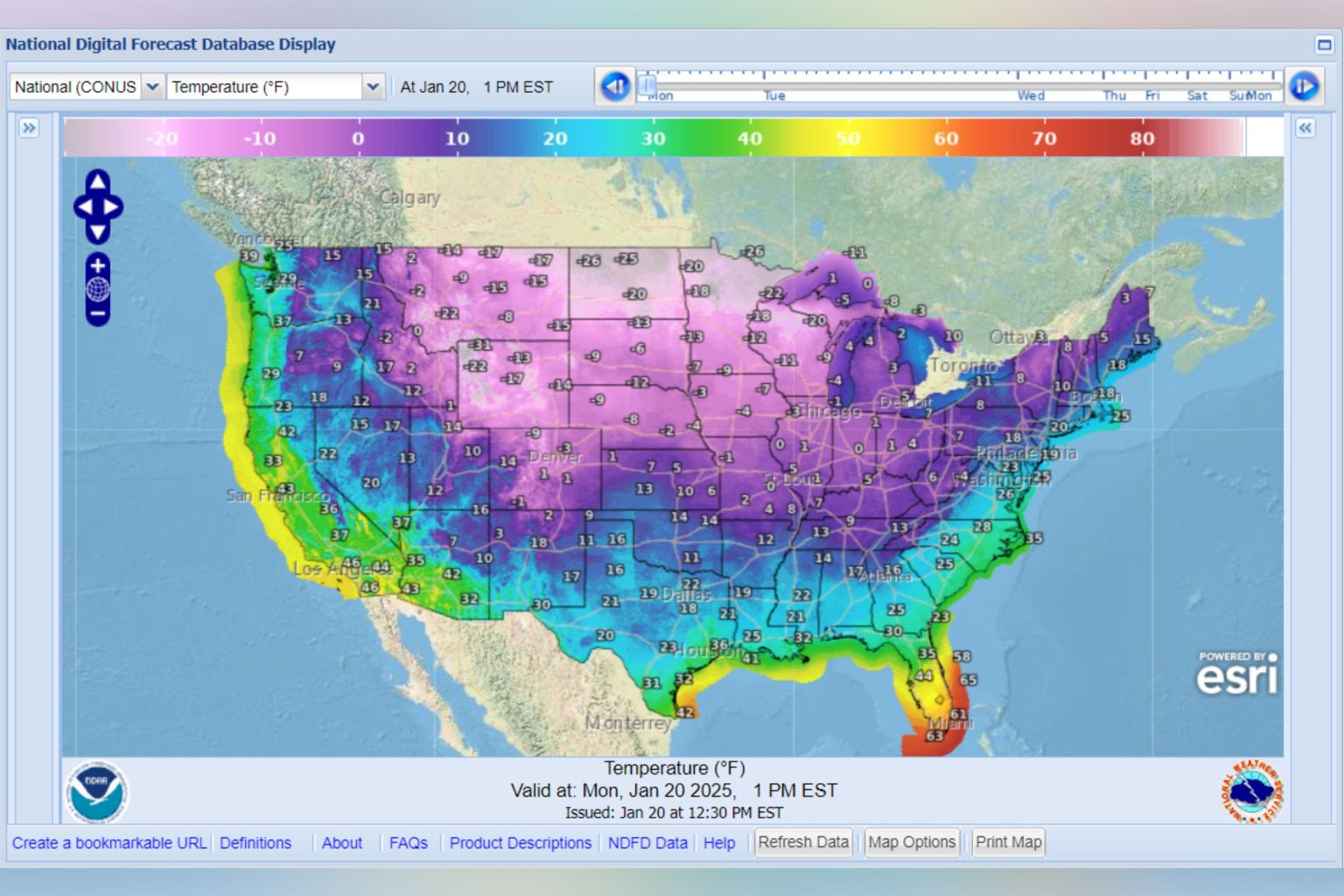
The United States braced itself for a widespread deep freeze as an arctic air mass descended from the Rockies, blanketing a vast swathe of the country in bitterly cold temperatures. This frigid incursion, predicted by the National Weather Service (NWS), threatened to disrupt daily life, impacting travel, increasing health risks, and potentially straining energy grids. The severity of the cold snap was underscored by projected temperatures far below January averages, raising concerns about the potential for significant disruption and hardship.
The NWS forecast painted a stark picture of the impending cold wave. By Monday afternoon, most of the contiguous U.S. would be gripped by sub-freezing temperatures. The northern reaches of the country were expected to bear the brunt of the arctic blast, with Minnesota and North Dakota facing temperatures plummeting to -26°F. Montana anticipated lows around -22°F, while northwest Wyoming braced for a bone-chilling -31°F. Even regions further south were not spared, with Indiana hovering around 0°F and northern Maine experiencing temperatures around 3°F. The chill extended across the southern states as well, with northern Georgia expected to see temperatures around 16°F and parts of the Texas Panhandle facing similarly frigid conditions.
The widespread nature of the cold snap meant that even typically milder regions were facing unusually low temperatures. Colorado anticipated temperatures dipping to -9°F in some areas, highlighting the reach of the arctic air mass. This pervasive cold outbreak underscored the potential for widespread impacts on infrastructure, transportation, and public health. The NWS warned that these frigid conditions would persist along the Gulf Coast and across the Southeast for much of the week, prolonging the challenges posed by the extreme weather.
Compounding the frigid temperatures, Winter Storm Enzo threatened to bring a mix of subfreezing temperatures, snow, and ice to the Gulf Coast states early in the week. This combination of extreme cold and wintry precipitation further heightened the risk of dangerous travel conditions and power outages. The storm’s arrival added another layer of complexity to an already challenging weather situation, underscoring the need for preparedness and caution.
The arrival of this arctic air mass was attributed to the expansion of the polar vortex, a powerful band of west-to-east winds that circulates in the stratosphere high above the North Pole. This vortex, a constant feature of the polar region, weakens in summer and intensifies during winter. In the Northern Hemisphere’s winter months, the polar vortex often expands, pushing frigid air southward along with the jet stream. This phenomenon can bring exceptionally cold temperatures to lower latitudes, as seen in this widespread deep freeze.
The NWS Weather Prediction Center emphasized the unusual severity of the cold wave, noting that forecast high temperatures across much of the country would be significantly below average, ranging from the negative teens and single digits in the northern Plains and Upper Midwest, to the teens and 20s in New England and the Mid-Atlantic, and the 20s and 30s in the Great Basin, southern Plains, and Southeast. This dramatic drop in temperatures highlighted the potential for significant disruptions to daily life, emphasizing the need for individuals and communities to take precautions against the cold. The prolonged nature of the cold snap further amplified the challenges, requiring sustained vigilance and preparedness in the face of the extreme weather.

