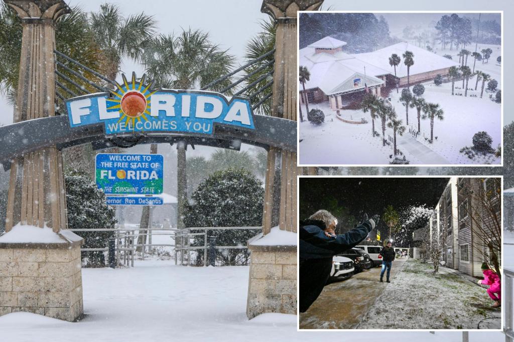
Florida braced itself for a significant winter storm on Tuesday, the most impactful since 1989, triggering airport closures and travel advisories across the western Panhandle. The storm unleashed heavy snowfall, ranging from 5 to 12 inches, primarily around the Pensacola area, leading to the closure of a 70-mile stretch of Interstate 10. The National Weather Service issued Winter Storm Warnings across a wide swathe of counties, from Pensacola to Jacksonville, cautioning residents about hazardous travel conditions due to accumulating snow and ice. Governor Ron DeSantis declared a state of emergency ahead of the storm, anticipating potentially record-breaking snowfall for the Panhandle, exceeding the previous state record of 4 inches set in Milton in 1954. This unusual winter event prompted concern and caution among Floridians, unaccustomed to navigating snowy landscapes.
The impending storm spurred utility companies along the I-10 corridor to prepare for potential power outages, particularly if significant ice accumulation occurred. FOX Weather meteorologist Steve Bender reported from a near-deserted Tallahassee, observing residents heeding the warnings and taking precautions after experiencing an active hurricane season. The heaviest snowfall targeted the Pensacola region, where reports confirmed accumulations of 5 to 12 inches by Tuesday evening. The hazardous conditions and resulting accidents forced the Florida Highway Patrol to shut down a substantial section of Interstate 10. Despite pretreatment efforts, roadways remained treacherous, highlighting the intensity of the winter storm. The official snowfall total in Pensacola exceeded 7.6 inches, with nearby Milton recording nearly 8.8 inches. The National Weather Service in Tallahassee anticipated a verification process spanning several days to confirm reports and determine if any location surpassed Pensacola’s snowfall total, potentially establishing a new state record.
The widespread impact of the winter storm rippled through various sectors, forcing school closures across districts from Jacksonville to Pensacola, including major universities such as Florida State University, Florida A&M University, the University of North Florida, and the University of Florida. Air travel was significantly disrupted, with Tallahassee International Airport canceling all flights from 3 p.m. Tuesday, aiming to resume operations by noon Wednesday. Jacksonville International Airport implemented similar cancellations, anticipating a return to normal operations by Wednesday afternoon. The region’s limited infrastructure for handling frozen precipitation, including a lack of treatment trucks and snowplows, further complicated efforts to maintain safe travel conditions on roads and at airports. Naval Air Station Pensacola also closed its main gate to all traffic due to the accumulating wintry mix.
This winter storm drew comparisons to the Christmas week snowstorm of 1989, a benchmark event for winter weather in North Florida and other Southeastern cities. That historic storm, which began on December 22, 1989, traversed Florida before exiting off the Atlantic coast, dumping significant snowfall across the region, including 15 inches in Wilmington, North Carolina, and nearly 2 inches in Jacksonville, Florida. The 1989 storm left a lasting impact, causing widespread power outages and substantial crop damage due to prolonged arctic temperatures. The current storm evoked memories of this event, serving as a reminder of the potential disruptions caused by significant winter weather in a region typically known for its warm climate.
The significant snowfall totals registered in various locations around Pensacola underscored the intensity of this unusual winter storm. The National Weather Service faced the task of meticulously verifying numerous reports to accurately determine the highest snowfall total and potentially rewrite the record books for Florida. This event highlighted the challenges faced by a region not typically equipped to handle substantial winter precipitation. The widespread closures and disruptions served as a testament to the storm’s impact, even as authorities worked diligently to restore normalcy and ensure public safety.
The storm’s passage prompted a collective response from residents, officials, and emergency services, all working to navigate the unusual conditions. The widespread school closures and travel disruptions aimed to minimize risks and prioritize safety amid hazardous road conditions and limited visibility. The event underscored the vulnerability of a region accustomed to a subtropical climate when confronted with a significant winter weather event. As Florida emerged from the storm’s grip, the focus shifted to assessing the full extent of the impact and implementing recovery efforts.

