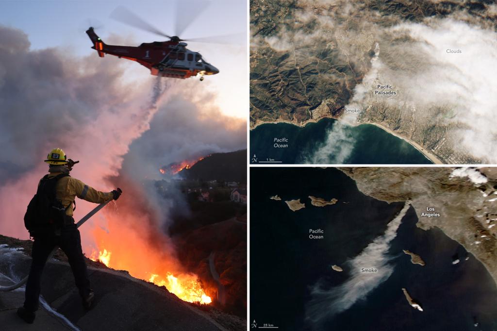
The devastating wildfires raging across Southern California in late 2023, captured in stark detail by NASA satellites and astronauts aboard the International Space Station, paint a grim picture of destruction and displacement. Images from NASA’s Sentinel-2 satellite, taken shortly after the eruption of the Palisades Fire, reveal a thick, gray smoke plume blanketing Los Angeles County and extending over the Pacific Ocean. Later images from the Aqua satellite show the smoke continuing to billow westward, a testament to the fire’s rapid spread which scorched over 11,000 acres in a single day. These satellite images provide a chilling overview of the fires’ impact on the region’s air quality and the vastness of the affected area. Astronaut Don Pettit’s photographs, taken from the ISS, offer a different perspective, showcasing the eerie glow of the fires illuminating the Los Angeles County hills from space, underscoring the intensity and scale of the blazes from a unique vantage point.
The multiple wildfires burning across Southern California collectively consumed at least 39,000 acres, a land area comparable in size to Brooklyn, New York. While firefighters made progress containing some of the smaller fires like the Sunset Fire, and achieving over 50% containment on the Kenneth and Hurst fires, the larger Palisades and Eaton fires remained active and destructive threats. The struggle to control these fires highlights the challenging conditions faced by firefighters, including dry terrain, strong winds, and difficult-to-access areas, emphasizing the complex and resource-intensive nature of wildfire suppression efforts. The sheer scale of the burned area underscores the significant environmental damage and the long-term recovery challenges that lay ahead for the affected ecosystems and communities.
The human cost of these wildfires proved to be tragically high, with at least 16 fatalities attributed to the blazes. Eleven lives were lost in the Eaton Fire and five in the Palisades Fire, with investigations ongoing to confirm all deaths as fire-related. Beyond the immediate loss of life, the fires disrupted the lives of hundreds of thousands of residents, with over 200,000 people forced to evacuate their homes. This mass displacement created a humanitarian crisis, requiring substantial resources and logistical efforts to provide temporary shelter, food, and other essential services to those affected. The scale of displacement highlights the vulnerability of communities to such natural disasters and the need for robust emergency preparedness and response systems.
The widespread property damage further compounded the crisis. Over 12,000 structures fell victim to the fires, representing a significant loss of homes, businesses, and community infrastructure. This widespread destruction not only represents a substantial financial burden but also signifies the loss of irreplaceable personal belongings and the disruption of livelihoods. Rebuilding these communities will necessitate a long and arduous process, requiring substantial financial investment, community planning, and long-term support for affected residents. The scale of the destruction emphasizes the urgent need for effective wildfire prevention and mitigation strategies to reduce the risk of future tragedies.
The satellite imagery and astronaut photographs provide a powerful visual record of the devastating Southern California wildfires. These images, combined with the reported statistics on acreage burned, fatalities, displacements, and property damage, paint a comprehensive picture of the scale and impact of the fires. They serve as a stark reminder of the destructive power of wildfires and the vulnerabilities of communities living in fire-prone areas. The ongoing efforts to contain the fires and provide aid to affected residents highlight the importance of coordinated emergency response, community resilience, and the need for long-term recovery strategies.
The 2023 Southern California wildfires underscore the increasing threat of wildfires in the face of a changing climate. The combination of dry conditions, high winds, and abundant fuel loads created a perfect storm for rapid fire spread and intense burning. These conditions are becoming more frequent and severe in many parts of the world, highlighting the need for proactive measures to reduce wildfire risk. This includes implementing effective forest management practices, promoting fire-resistant building materials and landscaping, and educating communities about wildfire preparedness. The lessons learned from these devastating fires should serve as a call to action for governments, communities, and individuals to prioritize wildfire mitigation and adaptation strategies to protect lives, property, and the environment in an increasingly fire-prone world.

