


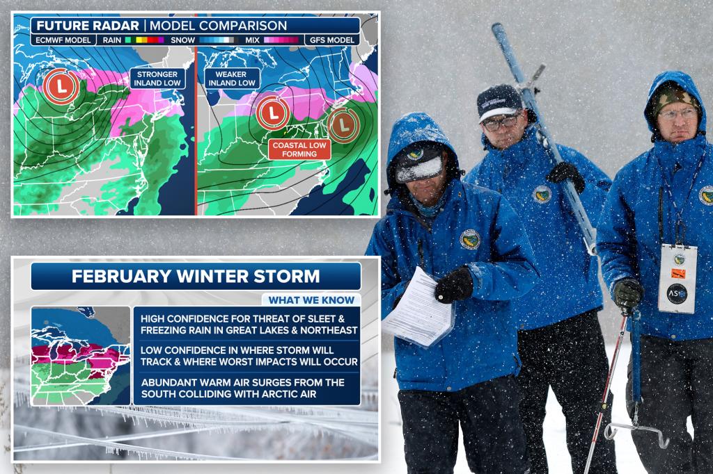
A significant winter storm is poised to impact portions of the Midwest and Northeast regions of the United States on Wednesday and Thursday, bringing with it the potential for hazardous travel conditions due to sleet and freezing rain. The exact track and intensity of the storm remain uncertain, making it difficult to pinpoint the areas that will experience the most severe icing. Meteorologists are currently monitoring two primary scenarios, each with distinct implications for the affected regions.
The first scenario involves a robust low-pressure system developing over the Plains and tracking eastward. This system is projected to interact with a potent jet stream transporting warm, moist air from the south. This confluence of atmospheric conditions could lead to significant freezing rain accumulation along the Interstate 90 corridor, stretching from the Midwest into the Northeast. Such an event would create dangerous travel conditions, particularly on bridges, overpasses, and highway ramps, where ice tends to accumulate more readily.
Alternatively, the second scenario envisions a weaker low-pressure system forming over the Plains while a separate, more powerful coastal storm develops along the East Coast. In this scenario, the coastal storm would dominate, potentially drawing the moisture away from the Midwest and concentrating the ice threat further east, primarily in New England. This scenario would result in less freezing rain across the Midwest but a heightened risk of significant icing in New England, posing similar travel challenges.
The uncertainty surrounding the storm’s development necessitates close monitoring and preparedness across a broad swath of the country. Cities along a potential impact zone, from Des Moines, Iowa, eastward to Syracuse, New York, are advised to be on alert for potential ice accumulation. Freezing rain can coat surfaces with a thin, transparent layer of ice, making roads, sidewalks, and other surfaces extremely slippery and dangerous for pedestrians and motorists alike.
The timing of the storm also presents challenges, as the freezing rain is currently predicted to impact the region during the morning and midday hours of Thursday, potentially disrupting commutes and daily activities. The combination of subfreezing temperatures and precipitation creates a particularly hazardous situation, as any accumulated ice will remain frozen and pose an ongoing threat. The potential for power outages also exists, as the weight of ice can accumulate on power lines and trees, causing them to break and disrupt electrical service.
As the storm draws nearer, forecast models are expected to refine their predictions, providing a clearer picture of which areas are most likely to experience the worst conditions and the anticipated ice accumulation amounts. This information will be crucial for emergency management officials and the public to make informed decisions regarding travel and safety precautions. Staying informed of the latest weather updates and heeding any advisories issued by local authorities is paramount in mitigating the potential risks associated with this impending winter storm. Preparing for the possibility of power outages, stocking up on essential supplies, and avoiding unnecessary travel are advisable precautions.


