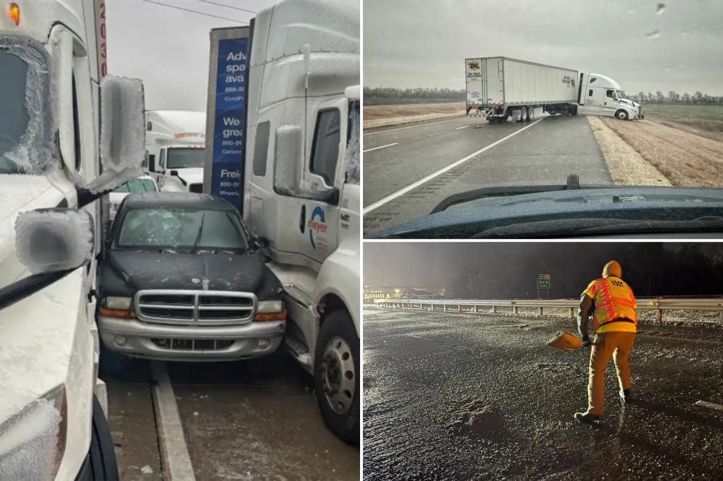
A potent winter storm swept across the central United States, bringing a treacherous mix of snow, ice, and plummeting temperatures, setting the stage for a disruptive eastward advance in the subsequent days. This “return of winter,” as characterized by meteorologists, was driven by a southward dip of the polar vortex, a phenomenon where the typically Arctic-confined mass of frigid air extends its reach into lower latitudes, delivering intense cold blasts to populated regions. This increasing frequency of polar vortex excursions is, in part, attributed to the rapidly warming Arctic, disrupting established atmospheric patterns.
The storm’s initial impact was heavily concentrated from central Kansas to Indiana, particularly along and north of Interstate 70, where heavy snowfall led to road closures and hazardous driving conditions. Accumulations exceeding a foot were predicted in parts of Kansas and Missouri, with the storm poised to track towards the Ohio Valley, then to the Mid-Atlantic states, promising significant travel disruptions and a hard freeze reaching as far south as Florida. Adding to the complexity of the weather system, severe thunderstorms, tornadoes, and hail were anticipated along the storm’s leading edge as it traversed the Lower Mississippi Valley. Simultaneously, parts of upstate New York were grappling with a lake effect snow event, burying the region under several feet of snow.
The immediate effects of the storm were evident in the numerous accidents reported across the affected areas. In Kansas, overturned vehicles, including a fire truck and several tractor-trailers, underscored the treacherous road conditions. Freezing rain in Wichita contributed to a surge in crashes, prompting authorities to urge residents to stay home. States of emergency were declared in Missouri and Arkansas, highlighting the severity of the situation and the potential for whiteout conditions that could strand motorists. The storm also snarled air travel, with Kansas City International Airport temporarily halting operations due to ice accumulation, causing widespread flight delays.
In anticipation of the worsening conditions, residents rushed to stock up on essential supplies, and warming centers opened their doors in churches and libraries. Businesses closed, and school districts prepared for potential closures. Transportation departments issued strong advisories, urging people to stay off the roads and warning of potential staffing shortages that could hinder snow removal efforts. Crews in various cities, including Columbus, Ohio, preemptively treated major roadways with anti-icing agents in an attempt to mitigate the impending ice threat. The combination of heavy snow and ice raised concerns about significant power outages, particularly south of the Kansas City area.
The storm’s frigid grip was expected to tighten its hold on the eastern two-thirds of the country in the following days, with dangerously low temperatures and wind chills forecast. Temperatures were predicted to plunge well below normal, creating a significant risk of hypothermia and other cold-related illnesses. Major cities like Chicago and Minneapolis experienced temperatures in the teens and single digits, respectively, while International Falls, Minnesota, plummeted to well below zero. These extreme temperatures underscored the far-reaching impact of the polar vortex intrusion.
The storm’s impact extended well beyond the initial snow and ice zone. Virginia, Kansas, Kentucky, Maryland, and several cities in Illinois declared states of emergency, highlighting the widespread concern and the need for proactive measures. Authorities emphasized the seriousness of the situation, urging residents to take precautions and prepare for hazardous conditions. Cities along the East Coast, including Annapolis and Baltimore, implemented emergency plans, opening free parking garages and activating shelters for vulnerable populations. Even as far south as Louisiana, the impending cold snap prompted a race against time to rescue a manatee spotted in Lake Pontchartrain, underscoring the widespread impact of the plummeting temperatures and the vulnerability of wildlife.

